Agriculture Integrated GIS Hub
Transforming agricultural development with data-driven visualization, monitoring, and management. A flagship initiative by the Govt. of Khyber Pakhtunkhwa.
About The Hub
Visualizing the Future of Agriculture in KP
What is the AgriGIS Hub?
The Agriculture Integrated GIS Hub is a flagship digital initiative by the Agriculture Department, KP, aimed at transforming how agricultural development activities are visualized, monitored, and managed.
This web-based platform consolidates spatial data from various directorates, offering a centralized dashboard for evidence-based planning. It embodies the department’s vision to embrace data-driven governance, improve service delivery, and enhance transparency and accountability.
Why It Matters
- Improve Planning: Make informed, data-backed decisions.
- Monitor More Effectively: Track project progress with GPS data.
- Enhance Coordination: Provide a unified view for all directorates.
- Promote Accountability: Create a transparent verification environment.
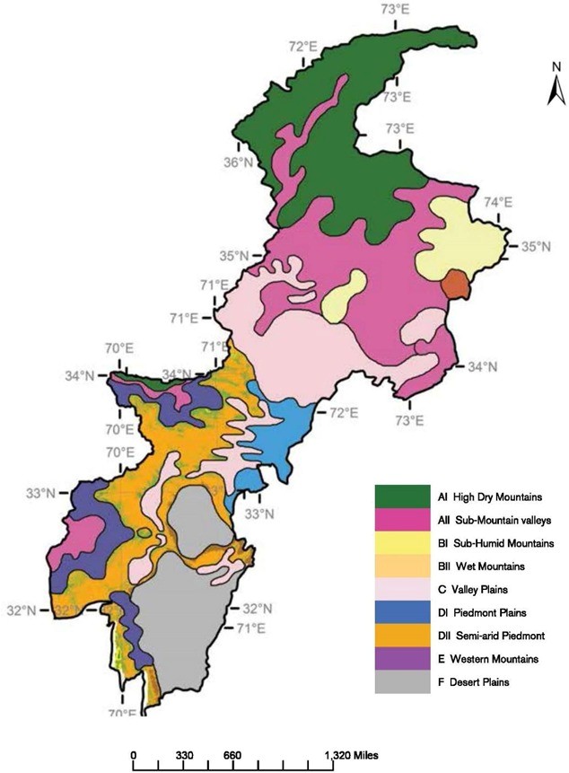
GIS Hub Coverage
Integrating All Wings of The Agriculture Department
Agriculture Extension
Farmer outreach, demonstration plots, and subsidy-based distribution.
Agriculture Research
Experimental farms, crop trials, and research across agro-climatic zones.
On-Farm Water Management
Irrigation channels, watercourses, solar tubewells, and micro-irrigation systems.
Soil & Water Conservation
Terracing, check dams, and water conservation projects in erosion-prone areas.
Agriculture Engineering
Machinery deployment, laser land leveling, and farm mechanization schemes.
Crop Reporting Services
Real-time crop data, reporting zones, and agricultural statistics.
Key Features
A Platform Built for Clarity and Insight
Interactive GIS Mapping
Visualize all agriculture-related interventions with geographic coordinates on a live map.
Location-Based Filtering
Filter activities by district, tehsil, project, department, or time period for focused analysis.
Pre, During & Post Visuals
View time-series imagery to assess project implementation stages and verify progress.
Directorate Dashboards
Access custom analytics and views for each directorate to monitor their respective portfolios.
Real-Time Reporting
Track the progress of schemes in real time with automated data updates from the field.
Full Mobile Accessibility
Access maps and dashboards from any device, anywhere, ensuring on-the-go management.
AgriGIS Hub Dashboard
Access the real-time GIS dashboard for agricultural interventions across Khyber Pakhtunkhwa. Explore live data, interactive maps, and project progress.
Go to AgriGIS HubResources
External GIS Tools & Maps
Publications
Featured Publication
Delineation and validation of GIS-based groundwater potential zones under arid to semi-arid environment using multi-influence factors approach
A GIS-based study identifying groundwater potential zones using multiple environmental and geospatial factors under arid to semi-arid conditions.
OUR TEAM

"Dedicated to digital transformation in agriculture."
Agriculture Department, KP